
Myrtle Beach and the Grand Strand
Lost a ring at Myrtle Beach?
From Cherry Grove Pier in North Myrtle Beach down past the Boardwalk and Surfside Beach to Pawleys Island.
The hour after you notice is worth more than the week after it. Nothing has been raked, nobody has walked the patch, and you can still stand where it happened and photograph it. A detector reads gold and platinum through dry or wet sand, so the job comes down to how well that hour is used and how many tides pass before a search.
Ring Seekers is a lost ring and jewelry recovery service that works with experienced local metal detectorists to search for a ring, wedding band, watch or phone lost in Myrtle Beach and the Grand Strand of South Carolina.
You deal with one person, who organises the search properly. We choose an experienced detectorist who knows your stretch of sand, brief them with your map and photos, and tell you honestly if the odds are poor. This page is for a wedding band, and just as much for an Oura ring, an earring, a bracelet, a watch, keys or a phone.
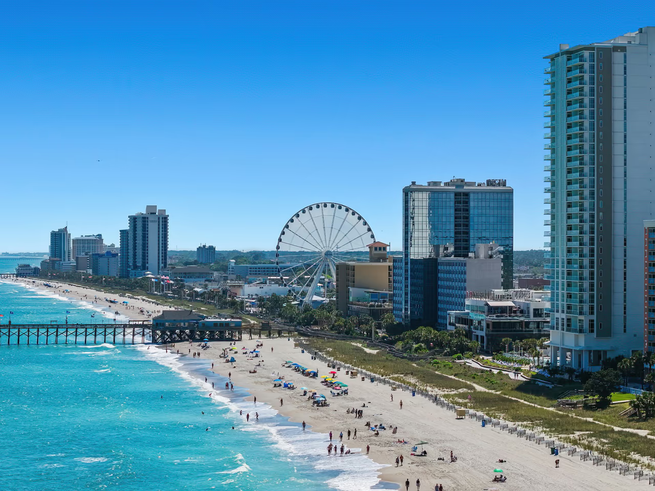
What that hour is for, Cherry Grove down to Pawleys
Fix the spot against things that do not move, such as a beach access number, a hotel sign or a pier. Photograph it both ways, drop a pin and note the time. Leave the sand as it is rather than digging around in it, because each hole in the wrong place shifts sand over what you are looking for.
Then send it all on WhatsApp with a picture of the ring, and add what a detectorist needs next: how deep you stood if you were in the water, which way you faced coming out, what you sat beside on dry sand, and whether anyone has raked the patch since. If there is a lifeguard nearby, ask before you go.
Places we cover in Myrtle Beach and the Grand Strand
- Myrtle Beach
- Myrtle Beach Boardwalk and Promenade
- SkyWheel Myrtle Beach
- Pier 14 (14th Avenue Pier)
- 2nd Avenue Pier
- Myrtle Beach State Park
- North Myrtle Beach
- Cherry Grove Beach and Cherry Grove Pier
- Surfside Beach and the Surfside Beach Fishing Pier
- Garden City Beach and the Pier at Garden City
- Murrells Inlet and the MarshWalk
- Huntington Beach State Park
- Litchfield Beach
- Pawleys Island
Beaches, piers and inlets on the Grand Strand where things go missing
The first thing we ask is exactly where you were.
Myrtle Beach Boardwalk and the SkyWheel
The Boardwalk and Promenade runs 1.2 miles along the oceanfront from the 14th Avenue Pier to the 2nd Avenue Pier, with shops, restaurants and the 187 foot (57 metre) SkyWheel along the busier part. The wheel is visible from most of the sand below, which makes it the quickest fixed point you have.
Pier 14 and the 2nd Avenue Pier
Pier 14 at 14th Avenue North is a fishing pier with a restaurant, and the 2nd Avenue Pier marks the other end of the Boardwalk. A phone or a watch that goes over a pier rail lands in water well out from the beach, which makes it a harder case than anything lost on the sand between them.
Cherry Grove Pier, North Myrtle Beach
Cherry Grove Pier, at 3502 North Ocean Boulevard, reaches 985 feet (300 metres) into the Atlantic. A wedding band lost in the surf beside it is searched from the beach around low tide; a phone dropped from the far end is a much harder job. How far along you had walked decides which of the two it is.
Surfside Beach and Garden City Beach
The Surfside Beach Fishing Pier is concrete and stretches 814 feet (248 metres) into the ocean. South of the town, Garden City Beach is unincorporated and sits partly in Horry County and partly in Georgetown County, with its own pier of about 668 feet (204 metres). Two piers on one stretch, so say which you were near.
Myrtle Beach State Park and Huntington Beach State Park
Myrtle Beach State Park keeps 1 mile of undeveloped beach, with maritime forest and a fishing pier, at 4401 South Kings Highway. Huntington Beach State Park near Murrells Inlet has 3 miles of beach, and the jetty is a 1.2 mile walk along the sand. Quiet sand holds a footprint, which helps more than you would think.
Murrells Inlet MarshWalk
The MarshWalk is a half mile wooden boardwalk along a natural saltwater estuary in the historic fishing community of Murrells Inlet, with eight restaurants on it. An earring or a set of keys dropped over the rail falls toward the marsh. A photo of the exact spot helps us most.
Litchfield Beach and Pawleys Island
Pawleys Island is a barrier island less than 4 miles long, about 25 miles south of Myrtle Beach, with Litchfield Beach just to its north in Georgetown County. There are no piers or towers to line yourself up against here, so the walkway you came down does that work instead.
What you get from Ring Seekers on the Grand Strand
One person on WhatsApp
You explain it once, and the same person handles it from the first message.
Your map and photos go to the detectorist
Before anyone walks onto the sand they have your pin, your photos and the time you lost it.
Plain about poor odds
A phone off the end of a pier or a ring lost in the surf with no idea of the spot is a poor bet, and we say so.
A five foot tide sets the hour
The waterline here travels a long way, so the useful part of the day is short and a detectorist picks the hour from the tide table, not the diary.
Cost first, then your answer
You know what a search would cost before you are asked to decide, and nothing moves until you have said so.
Tide, surf and sand from Cherry Grove to Pawleys Island
What a detectorist works with on this coast.
Tides
NOAA station Springmaid Pier (8661070): mean range 5.02 feet (1.53 metres), and 5.6 feet (1.71 metres) between the higher high and the lower low. A ring lost at the waterline in the afternoon may be well under water by evening. Anything lost in the surf is best searched around low tide.
Rip currents and flags
Rip currents form at breaks in sandbars and near piers and jetties, and often run faster around low tide. Myrtle Beach lifeguards reported new rips around 8th, 10th and 12th Avenue South after renourishment (WMBF News, 10 August 2026). A single red flag means strong waves or currents, double red flags worse.
Water temperature
The NOAA sensor at Springmaid Pier averaged 82 to 85 F (28 to 29 C) in July and August of 2024 and 2025, and 48 to 52 F (9 to 11 C) in January. Cold water shrinks fingers, so rings and Oura rings slip off more easily in cooler months.
Fresh sand on the strand
Parts of this coast are rebuilt with sand pumped in from offshore, which is why the lifeguards noticed the sandbars had changed. New sand is soft and deep, and something dropped on it in the last hour is still in the top of it.
Sand, boards and marsh
Three surfaces here. Open sand is worked in lines around low water. Anything that falls between boardwalk boards drops straight down and travels nowhere. Over the MarshWalk rail it is estuary mud, slower and softer work again.
Want a first idea of your chances? Try the lost ring recovery calculator.
The questions that come in while the sand is still fresh
It came off an hour ago near the SkyWheel. What do I do right now?
Stop walking over the patch, then take two photographs from where you were standing: one with the 187 foot (57 metre) SkyWheel in it, one facing the sea. Drop a pin, write down the time, and leave the sand exactly as it is. If it came off in the water, the state of the tide at that moment is what tells a detectorist where the waterline was.
I was walking the Boardwalk when I noticed. How do I narrow that down?
Work backwards along it. The Boardwalk and Promenade runs 1.2 miles from the 14th Avenue Pier to the 2nd Avenue Pier, so the useful question is where you last remember having it. Name the two or three places you stopped rather than the whole walk, and a mile of oceanfront becomes three small patches.
My phone went off the rail at Cherry Grove Pier. Can a detector find it?
A detector picks up a phone or a watch happily enough, but the water under a 985 foot (300 metre) pier is a different job from a beach search, and we will tell you plainly if it is out of reach. Metal framed sunglasses show up; plastic ones are spotted by eye or by a diver. Tell us how far along the rail you had walked.
I lost an earring on the MarshWalk in Murrells Inlet. Is that worth a search?
It depends where it landed. The MarshWalk is a half mile wooden boardwalk beside a saltwater estuary, so an earring either sits between the boards or goes over the edge toward the marsh, and those are two different jobs. Tell us which restaurant you were nearest and send a photo of the spot.
We lost a ring at Pawleys Island or Litchfield Beach. How do we describe where?
By the access and the house behind you. Pawleys Island is a barrier island less than 4 miles long, about 25 miles south of Myrtle Beach, with Litchfield Beach just to its north, and neither has the piers and towers that make the Grand Strand easy to point at. Photograph the dune line from where you sat and count the walkways.
My Oura ring came off in the surf at Surfside Beach. Which way does it go?
Down rather than along, in the first hours. The Surfside Beach Fishing Pier is concrete and runs 814 feet (248 metres) into the ocean, which gives you a line to quote a distance from. An Oura ring reads on a detector like any other ring. Tell us how far from the pier you were and which way you faced coming out.
Should I rent a detector and look for it myself in the meantime?
If it is dry sand and a patch you can stand on, have a go. The catch on a strand this busy is that a borrowed machine sings at every bottle cap, and telling those from a ring is the part that takes practice. Mark the patch first, and if an hour gets you nowhere, send us the photos.
Myrtle Beach and the Grand Strand
Do the photos now, read this again afterwards
Two pictures, a pin and the time, while the hour is yours.
Everything gets harder once the tide has been over it twice, so the order matters: mark the patch, photograph it both ways, then message us with the beach and the time. You will hear back what kind of search this is.