
Maracas Bay and the North Coast Road
Engagement ring lost at Maracas Bay?
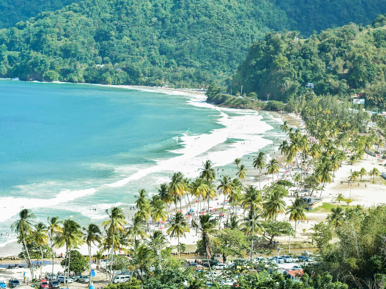
Maracas Beach and the far end of the bay, the real Tyrico Bay, Las Cuevas and the Maracas Lookout.
A search for an engagement ring lost in the Maracas surf is possible, and its chances rest on two things: whether it went in the break close to the sand or farther out, and how exactly you can mark the stretch of beach where you were swimming.
Ring Seekers is a lost ring and jewelry recovery service that works with experienced local metal detectorists to search for a ring, wedding band, watch, keys or phone lost at Maracas Bay or along the North Coast Road in Trinidad and Tobago.
Tell us what happened and where. We choose an experienced detectorist who knows the north coast, brief them with your map and photos, and tell you honestly if the odds are poor.
At Maracas Bay and at Las Cuevas a headland closes off each end of the beach, so a photo with one of them in the frame helps place you.
Before you drive back over the Saddle Road
If the ring went in the water, keep every photo from that day, and add one now from the edge of the sand that shows the nearest hut or palms with a headland behind. Save the spot on your phone's map as well. Write down the hut, picnic table or stall you were closest to, and whether you used the change rooms or went back to the car before you noticed.
Maracas Beach is the western part of Maracas Bay, with the fishing village and a hotel at that end. Visitors call the eastern end of the same bay Tyrico, but Tyrico Bay proper is a separate beach farther east, and Las Cuevas is farther along the North Coast Road again. Tell us the name you used and what you could see from your towel, and we will work out which beach it was.
Places we cover around Maracas Bay and the North Coast Road
- Maracas Beach
- The eastern end of Maracas Bay
- The Maracas fishing village
- The Maracas River and the other river mouths
- The backshore huts and picnic tables
- The Maracas car park and food stalls
- The Maracas Lookout
- Tyrico Bay
- Las Cuevas Bay
- The Las Cuevas beach facility
- The Las Cuevas fishing facility
- The Cuaraguate River at Las Cuevas
- The North Coast Road from the Saddle Road
Along the mountainside road to Maracas, then east to Las Cuevas
The fishing village and the lookout are on the list as well as the sand.
Maracas Beach
The beach runs for approximately 1.8 km of fine, off-white sand that slopes moderately into the sea. Unlike other north coast beaches, it is backed by a large coastal plain planted with almond trees and coconut palms, with huts and picnic tables on the sand. On a beach that length, the tree or hut you were next to matters.
The fishing village and the river mouths
A fishing village and a hotel sit at the western end of the bay, and three rivers enter the bay at that end. Only one of them, the Maracas River, runs all year. A loss near a river mouth needs one extra detail: which side of the water you were on.
The car park and the stalls
The car park is south of the North Coast Road, on the other side from the beach, and vendors sell bake and shark and other local dishes from stalls on the backshore and in the car park. Keys and phones taken out to pay belong on the list.
The Maracas Lookout
The lookout is a stop with a view of Maracas Bay against the mountains, where local vendors sell souvenirs. If a phone went missing that day, count the lookout as one of your stops.
Tyrico Bay
Tyrico Bay is a beach of its own with a laid-back feel, where families come for picnics. If you ate there, the picnic spot is somewhere to start, and because rip currents occur at Tyrico too, say whether the item went in the water or on the sand.
Las Cuevas Bay
Las Cuevas is reached along the North Coast Road east of Maracas. Its gently sloping beach of grayish-brown fine sand lies between two headlands, Las Cuevas Point in the west and Abercromby Point in the east. Low, steep cliffs back the eastern half, with the beach facility on top of them and a fishing facility at that end, while the western half is backed by low-lying land.
Between your message and the search
Your messages reach one person
Every message you send, from the first photo to the question of how it went, lands with the same person, who also briefs the detectorist.
Photos toward the trees and the headlands
Those shots from where you came out of the sea are what the detectorist lines up with on the day, so they go across exactly as you took them.
Rough water, beyond the break
If you were out past the breaking waves on a rough day, that is a long shot, and you would hear that from us first.
No pressure on the cost
We explain the costs before any search is booked, and there is no pressure to say yes on the spot.
What the sea does on this stretch of coast
Waves come in from the north and northeast, and rip currents are found at both beaches.
Plunging waves and two-way currents at Maracas
Waves reach Maracas from the northeast and plunge as they break, and swimming and body surfing are popular here. Strong currents run along the shore in two directions, to the northwest and to the southeast, and rip currents are usually present, so tell us whether you drifted along the beach before you came out.
November to April
From November to April, when the seas are rough, waves at both Maracas and Las Cuevas can reach 1.5 m. Give us the date of the loss so the detectorist knows what the sea was doing that day.
Two different halves at Las Cuevas
The eastern end of Las Cuevas is sheltered and the current along the shore is weak there, and the lifeguards patrol that part of the beach. The western section is where people surf. Say which half you were on before anything else.
Want a first idea of your chances? Try the lost ring recovery calculator.
Questions about Maracas Bay and the North Coast Road
A wave caught me while body surfing at Maracas and took the engagement ring. Is the surf too much for a search?
Not by itself. The waves at Maracas plunge as they break, but where you were standing when that one hit tells us more than the surf does, because the break near the sand is a very different search from the water beyond it. Pin the place where you came out, and say what time it was and whether a lifeguard flag was near you.
Could car keys that were in a beach bag at Maracas be in the car park rather than on the sand?
They could be in either. The car park is on the far side of the North Coast Road from the sand, and some of the food stalls are in the car park too, so check around the stall and the car before anything else. Then send us a pin for where your bag sat on the beach, the stall you ate at, and the row you parked in.
We were playing ball on the backshore at Maracas, and afterward a bracelet was missing.
The backshore is the wide ground behind the beach, planted with almond trees and coconut palms, where the huts, picnic tables and some of the stalls stand. Name the hut or the trees nearest the game, roughly how far the play ranged, and whether it spilled down onto the sand at any point.
Does a watch lost after a swim at Tyrico Bay count as Maracas?
It depends which Tyrico you mean. Visitors give that name to the eastern end of Maracas Bay, while Tyrico Bay itself is a separate beach farther east, and one photo from your spot settles it. Rip currents are found at Tyrico as they are at Maracas, so tell us whether the watch was on your wrist in the water or left with your things on the sand.
Where on Las Cuevas do people surf? My Oura ring went while I was out on a board.
In the western section, which is backed by low, flat land with the Cuaraguate River winding through it, so the river is the marker to use. Tell us how far from it you were sitting on the board, and whether the ring came off paddling, in a wipeout or back on the sand.
Is the sheltered end of Las Cuevas better ground for a lost earring?
The water is sheltered there, which helps. It is the eastern end, backed by low cliffs, where the lifeguards patrol and the current along the shore is weak, on a beach that slopes gently into the sea. Send a photo of the other earring, a pin, and a note of whether it came out in the water or on the sand. The fishing facility at that end and the beach facility on the cliff top both work as markers.
I last had my phone out at the Maracas Lookout, taking a picture of the bay.
The lookout is a stop with a view of the bay, where people take photographs and local vendors sell souvenirs. If you drove on to the beach afterward, the phone could be at either place or in the car. Search the car properly first. A photo someone else in your group took at the lookout shows where you stood, and its time tells us how long before the beach you still had the phone.
A necklace went near one of the rivers at the west end of Maracas Bay. Do you need to know which one?
Yes. Three rivers enter the bay at that end, and only the Maracas River flows all year, the other two being seasonal. Tell us which one it was, whether you were standing in the river, in the sea or on the sand between them, and what the necklace looks like. The fishing village and the hotel at that end of the bay make good markers for a pin.
Maracas Bay and the North Coast Road
Tell us which bay, even if you are unsure of its name
A blurry photo of your spot on the sand is still worth sending.
Say what is missing and whether it happened in the water or on the sand. Put a pin where you were, then send both to us on WhatsApp.